.

.
HOME OF THE LADY DENMAN - Local history isn't always about the big story - the everyday story of life in the early development of the region can be a fascinating, entertaining and educational journey.
Showing posts sorted by relevance for query point perpendicular lighthouse. Sort by date Show all posts

1 May 2014

Point Perpendicular Lighthouse.

lightOn this day May 1st 1899.
If you visit Jervis Bay bay, you cannot miss the iconic vertical cliff that dominates the distant view and forms the northern headland of the Bay.
Take a walk along the shore at night and you will see a bright cycling light sending a long beam across the open sea and the waters of the bay.  That light is emanating from Point Perpendicular Lighthouse and is a beacon for passing ships giving them a location, and reminding them of the danger of straying to close to shore.
Image taken 2002.


1899 saw the opening of the majestic white sentinel atop the steep 300ft high cliffs of Point Perpendicular overlooking the entrance to Jervis Bay.  The lighthouse guided ships safely along the south coast until it was decommissioned and replaced in 1993.

1962-Lighthouse 1984-Lighthouse

1962

              1984


IMG_4717The original lighthouse has been replaced by a solar powered, skeletal steel framed automated light, it doesn’t have the same style or romance of the old light, but it still keeps the passing ships on course. And on special occasions they relight the old light and it’s a sight to behold.
Shown here in full operation during the fleet review October 2013.


fleet-review-2013The old light is much brighter than the new light.
The light is so bright it casts light around the shore line of the bay.


light-2The Point Perpendicular Lighthouse was built to replace the Cape St George lighthouse which was built in the wrong location in 1860. Built to far south from the entrance of Jervis Bay, it was deemed a navigation hazard and was decommissioned when Point Perpendicular Lighthouse came into operation.
The undignified end came via the navy who demolished the light by using it for gunnery practice in 1922.


light-6 light-3 light-from-the-water cape-st-george-lighthouse-panna

Location map

Point Perp. from south

Cape St George

Ruins looking south

-Mrs-William-Parker The Keepers.
The first keeper, William Parker was previously the light keeper of Cape St George Lighthouse, the assistant keeper Arthur Bailey was the son of Edward Bailey, the late keeper of Cape St George Lighthouse.
The last keeper was John Hampson.

This beautiful image is of Mrs.William Parker the first light house keepers wife.


Last Keeper Pt Perpendicular bbr
The last keeper, John Hampson,
waves goodbye
Photograph: The Bay And Basin Review


The image below shows the ruins of Cape St George Lighthouse in the foreground, and Point Perpendicular on the headland in the far distance.
light-4


Fact sheet.
Height: 21.4 meters high and 93 meters above sea level.
Build: Believed to be the first lighthouse in NSW to be built of Concrete blocks.
The tower is circular, with an internal diameter of 11 feet 9 inches (3.58 m). It is 44 feet (13 m) to the balcony.
Light Source: The original light source was a vaporized kerosene lamp with an intensity of 100,000 cd and  a visible range of around 33 kilometres (21 mi)
In 1964 the light was electrified, 2 diesel engines serving as the power source.
Intensity: 1,200,000 cd
Range: 26 nautical miles (42 kilometres
Automated, demanned and deactivated in 1993.


Previous story and images of Cape St George Lighthouse – Continue reading
Point Perpendicular 2002 -  Ruined Cape St George lighthouse images

REF:
http://www.lighthouse.net.au/lights/nsw/Point%20Perpendicular/Pt%20Perpendicular.htm
http://en.wikipedia.org/wiki/Point_Perpendicular_Light
Go here to see some amazing images from inside the lighthouse.

27 June 2017

Government pilot steamer, S.S Thetis.

imageCopyright free. https://www.flickr.com/photos/anmm_thecommons/8966369784

S.S.Thetis was built in 1868 for the New South Wales Department of Public Works.


A regular visitor to Jervis Bay, she was most famously involved in the search for the S.S. Dandenong which floundered off Jervis Bay in 1876 with the loss of 40 lives.

1870 - The Thesis was sent out to examine the coast off Jervis Bay, The brig Spec from Melbourn had passed a piece of wreckage consisting of the roundhouse of a ship.  It was painted red on the top, and sliding hatch,  the main boom of the vessel was lashed to the house,  and what appeared to be the bodies of two men were lashed to the boom. More wreckage was spotted a few days later.  The Thesis could not find the wreckage.

1870 - She visited the bay and opened telegraphic communications with Sydney.

1870 - She called into Jervis Bay to inspect the Cape St George lighthouse which required the officials to leave the ship near Bristol Point and travel by foot overland. After the inspection, they headed to the wreck site of the ill-fated Walter Hood just north of Bendalong. The Walter Hood was wrecked during a heavy gale in April of the same year.
The gale drove her onto rocks, 12 souls perished with the survivors fighting a desperate battle for survival as the remains of the vessel broke apart around them.  At this stage there was no wreckage showing above the water,  the hull appeared to be lying right in the breakers, a diver was sent to inspect the wreck but because of the breakers, he was unable to make any careful examination of her remains.

1873 - Thesis came to the aid of the steamer Hero which had been reported missing,  but she had put into Jervis Bay short of coal. The Hero had her top-gallant forecastle washed away during a severe gale.  The Thesis supplied the Hero with coal. The passengers of the Hero presented Captain Logan with a purse of Sovereigns because of his efforts to keep them safe during the gale.

1896 - The Thetis arrived in Jervis Bay with members of the Marine Board for an inspection of the Cape St George Lighthouse. It was found to be in good order and left for Kiama and Wollongong.

1898 - The Thetis was fitted with nets and was sent on a mission to test the fishing grounds along the coast,  she intended to work the grounds off Jervis Bay but a boiler pipe burst and she returned to Sydney for repairs.

1898 - Arriving in Jervis Bay she trawled nets but the trial was deemed almost useless, with masses of seaweed and worthless fish secured being fourfold the number of edible fish.

1899 - During one excursion to Jervis Bay the Thesis was involved in an experimental fishing technique, where a series of electric lights were attached to a wire netting cage,  with a view of trawling for fish at considerable depth. The experiments failed during the day in deep offshore waters,  with some of the lights breaking.
Experiments were then conducted at night in Jervis Bay. The steamer anchored in 6 to 8 fathoms of water lowering the cage with the lights, the lights were so powerful they illuminated the whole of the water around the vessel, and though it was not possible to see the fish swimming near the globes they could be observed a short distance above the lights.
The cage was left down for about and hour and a quarter,  and upon being drawn to the surface the globes were found to be intact,  but there were no fish in the cage. The gentleman who invented the apparatus is of the opinion the lights were so strong the fish could at once see the cage.

1899 - The Thetis arrived in Jervis Bay carrying an official of the Works Department for the final inspection of the new Point Perpendicular Lighthouse before the official handover to the Marine Board. The officials were landed at the Government wharf at Benjajine Beach near present day Honeymoon Bay before walking to the lighthouse on the service track.


image

S.S Thetis at the loading wharf for Point Perpendicular Lighthouse

1900 the Thetis while on a voyage to Wagonga River
to investigate complaints about the way the fisheries were being worked was forced into Jervis Bay by very heavy weather. She anchored near the Miranda Lagoon, described as a large sheet of water running back about a mile,  ( as far as I know there is no lagoon inside Jervis Bay called Miranda,  there are two possible places, one being Moona Moona Creek the other being Hare Bay, that could be described as a lagoon with the dimensions described below.)

The lagoon was described as being an average width of two chains. ( A chain is a unit of length. It measures 66 feet or 22 yards)  A large sandbank was formed across the mouth and a Mr Want directing that a channel should be made to connect it with the waters of the bay.  All hands were engaged in the work,  and after some considerable labour a narrow passage was cut,  and in a very short time, the mouth widened to thirty or forty feet,  caused by an immense volume of water forcing it's way out. The lagoon was found to be alive with mullet, bream, eels and myriads of small fish. 
They were surprised to find such and array of fish living in such brackish water highly charged with vegetable matter.

It was presumed that the entrance had been closed for some considerable time and the cutting of the channel to admit a free passage of water to and from the lagoon would be of great value to the fish in these waters.

Shortly after the Thetis resumed her voyage.


Continue reading about the Walter Hood  - http://jervisbaymaritimemuseum.blogspot.com.au/search?q=walter+hood
Continue reading about the Dandenong -  http://jervisbaymaritimemuseum.blogspot.com.au/search?q=dandenong


image


7 October 2016

Point Perpendicular Lighthouse.

The fire on Beacroft Peninsula was caused by a backburn operation that quickly went out of control yesterday and provided holiday makers and locals alike with a spectacular light show last night.  The fire at one stage was heading straight for the historic Point Perpendicular Lighthouse.   Backburning by the Bushfire Brigades created a barrier and the threat was averted.

I was up very early this morning and looked for another vantage point to shoot the fire.  To say the vision was amazing is an understatement.

2r

Pre dawn long exposure,  The headland was shrouded in smoke which was being blown out the sea.

9

The sun was still just below the horizon when I shot this picture. The fire was burning right to the edge of the cliff.

11

Wide view showing the wide spread fire front. The light was just spectacular.   The sun was just above the horizon but subdued by the smoke. Point Perpendicular stood out as a large dark mass compared to everthing around it.  Quite amazing to see.

IMG_9960
15


BACK


30 September 2013

Point Perpendicular Lighthouse

Point Perp Alight ic During the current Navy Celebrations in Jervis Bay the original Grand Old Lighthouse sitting atop the majestic northern cliffs of Point Perpendicular has been put back into service.

If you go down to the bay at night you will see it’s bright light blazing across the dark sky.
It’s a fantastic thing to experience, and even better if you go out to the light itself.

The lighthouse has just undergone extensive refurbishment financed by the Department of Defence, it’s never looked better and a perfect time to visit this beautiful piece of local maritime history.

Photograph: Ian Clifford


navybrand3d-small More information available here

ABC News Local Stories
Point Perpendicular lights up for Fleet Review

15 September 2016

Cape St George.

After being replaced by the Point Perpendicular Lighthouse, The Cape St George Lighthouse was still causing concern and confusion for coasting vessels,  especially when the white painted  tower would almost glow under a bright full moon.    The authorities deemed the old light a navigation hazard and the navy was employed to use the tower for target practice and bring it down.  What you see now are the remains of the once beautiful hand made lighthouse, strewn across the ground just the way it was after being demolished in such an undignified way.

By visiting the old ruins you will get a magnificent view of the Point Perpendicular Lighthouse.

light

The museum has on very interesting collection of artifacts from the lghthouse on display.  It’s well worth the effort to come along to the museum and delve into the local history.
light-2016

If you would like to see other posts and photographs of the old light, type Cape St George into the search box on the right…

BACK


18 August 2017

On this Day

Today 18th August 2017.
This weekend the Old Point Perpendicular Lighthouse will come back into operation as part of the
16th annual International Lighthouse and Lightship Weekend. The light was built in 1899 to replace the Cape St George Lighthouse which was built in the wrong location.   In 1993 due to rising operating costs, the lighthouse was decommissioned and replaced with a steel tower structure that was operated by Solar panels.
The old light is a lot brighter and revolves in an anti clockwise rotation. It is well worth the trouble to make your way to the waters edge to see this rare event.
The light will be operational until Sunday Night.

http://www.lighthouses.org.au/lights/NSW/Point%20Perpendicular/Pt%20Perpendicular.htm

image


john-jervis-2Two more historic events occured on this day.

The first was 229 years ago on the 18th August 1788 when the transport ship the Atlantic under the command of Archibald Armstrong entered Jervis Bay.
The naval agent was Lt. Richard Bowen,  during their time in the bay, Bowen charted and surveyed the bay,  and named the discovery “Port Jervis” in honour of Sir John Jervis.


Continue reading about Richard Bowen.


Sir John Jervis.

IMG_2513

The Atlantic sailing past Point Perpendicular as she entered Jervis Bay,  as depicted by Ian Henson.


The second event occured 171 years ago and would forever link Coollangatta in Queensland with the Shoalhaven when on the 18th August 1846. The brigantine “The Coolangatta”, named by Alexander Berry after his station which in turn was named after Mount Coolangatta, was wrecked in a storm. The place was between Point Danger, where the boundary between NSW and Queensland was made in 1859, and Cut Hill. The place was called Coolangatta after the wreck of the ship.
Continue reading about the Coolangatta.


Advertising  The Shoalhaven News and South Coast Districts Advertiser Sat 18 Aug 1923.

Take notice of the Telephone number!

image


image


12 December 2017

Crookhaven Heads Lighthouse

IMG_5570As it appeared in 1908.

1
The Crookhaven Headland where after a short walk you will find the remains of the lighthouse.
imageAs it appeared in 1905. This shows the headland almost cleared of trees and scrub.


Early today I took a walk out to the Crookhaven Heads Lighthouse,  It has been quite a few years since I last visited the historic lighthouse and I didn't know what to expect considering the state it was in on my last visit.

History.

During the age of sail and coastal steamers, Crookhaven Heads was a busy waterway, being the only access to Shoalhaven River vessels would cross the shifting sandbars in all sorts of weather taking their cargo and passengers to and from Nowra. The lighthouse played a vital roll in providing safe navigation through these sometime treacherous waters.

1872 - A red light made from a ship's masthead light supported on two poles was exhibited by boatmen at the river entrance.

1882  - The first aid to navigation was a timber light,  constructed on the beach 200 meters to the west of the current lighthouse consisting of a brass lantern.

1904 – The current brick structure was built on the headland overlooking the entrance to the river. The lantern was from the former Cape St George Lighthouse which was replaced by Point Perpendicular Lighthouse in 1899.  The name of the station was then changed to Crookhaven Heads.

map

The lighthouse today is in a very sorry condition. 
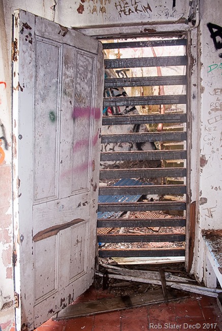
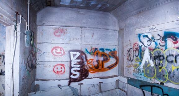
Today the headland is covered in well grown trees and scrup hiding the lighthouse from view, it's isolation has seen continuous vandalism over many years with all the windows smashed, doors ripped off, graffiti scribbled from top to bottom over the inside of the building and rubbish strewn about.  Attempts to secure the building have seen the main windows fitted with steel panels inside and out,  a steel slat door stops vandals from accessing the old stairwell.

IMG_5564

1909 - The lighthouse was completely renovated but due to its isolated and overgrown location, this community work was quickly undone and we find the old light as it is today.  A recent repaint of the outside has what remains looking clean and tidy, I wonder how long this will last.

Untitled_Panorama1Photo from my last visit in 2010.

2010 – Because of continued vandalisation the historic lantern was carefully disassembled in December 2011 and removed from the location by a navy helicopter from HMAS Albatross for restoration.


IMG_5568Permanently fixed heavy steel bars across the doorway blocking entry to the tower stairs.

inside-crooky-lighthouse-2017
2
Vandalism 2017.
What will become of this historic monument?

The headland still dominates the entrance to Crookhaven River and now has a sinle automated light on top of a steel pole.

The waterway is still busy, with trawlers and pleasure boats coming and going on a daily basis.  The Pilot station still monitors all boating in and out of the river and plays  a vital roll in the safety of sea farers today.


I have done a few posts on Crookhaven Heads which include many of the ships that came to grief in and around the entrance to the river.  It's quite a fascinating tale and well worth reading.
Continue reading.


image


17 December 2018

Point Perpendicular Lighthouse

1899
May 1909 - JERVIS BAY LIGHT

The Department of Navigation notified that an incandescent Welsbach mantle lamp, using petroleum vapour is now installed in the lighthouse at Point Perpendicular, having. been first displayed on March 17th. The improved light is of approximately 1200 candlepower, while the former oil light was only about 300  (intrinsic candlepower without the effect of the lens). The character of the light remains the same, viz, three short successive 'flashes every 20 minutes but the light will be seen at a greater distance in hazy weather.

Welsbach Lamp.
The Welsbach Lamp was invented by Auer von Welsbach in 1885. The Welsbach mantle was made from silk impregnated with zirconia. It burnt at least three times brighter than what was previously known.


Continue reading about Point Pependicular Lighthouse.


image


23 April 2015

Jervis Bay snippet.

It’s well worth reading this story, it gives us a fascinating look at Huskisson and the Bay in 1899, shooting, fishing and camping, the hospitality and interaction of strangers.

Shoalhaven Telegraph December 17th 1899,
CAMPING AND FISHING AT JERVIS BAY
.
It details two men’s holiday at the bay and gives us some interesting details of their trip, of Huskisson and surrounds and the relaxed attitude of the time.


My brother, Dr S------, with a busy practice in an inland town of New South Wales, feeling the want of rest and a complete change for a month,  invited me to join him in a fishing trip,  and having visited the bay similarly about six years ago,  I proposed the same place for our tour,  as being in every way suitable.

We left Redfern station on Monday morning early in April by the 8.30 train,  and after a very pleasant journey through the Illawarra country,  reached Nowra at 1 o’clock – in good time for a wash and dinner at a good hotel.

We arranged for a two horse buggy to drive us and all our traps to the bay,  distance 16 miles,  and after purchasing a liberal supply of provisions made a start about 3.p.m.   The road is an excellent one - very suitable for cycling - and the weather being lovely,  we enjoyed the drive immensely.

The village of Huskisson,  as the chief settlement at the bay is called,  is old,  but very quiet and small,  and consists of a public school,  post office,  sawmill,  hotel and store combined,  and a few scattered cottages and fisherman's humpies.  it is prettily situated on the banks of a large creek,  at the entrance of which is a good wharf for the vessels engaged in the timber trade
.
We drove a mile further on,  to a good camping ground at Moonie Creek,  and at once proceeded to put up our tent and make snug for the night.

I would here like to describe our bunks,  which are easily made,  and are most comfortable.  Two large sacks are placed end to end and stretched on stout saplings,  supported by uprights spread as an angle of about 40 degrees,  sunk in the ground,  and lashed at the top.

We rowed from Huskisson to boat harbour, taking 2 hours.
After a hearty camp tea and smoke,  we turned in early and slept the sleep of the just.  Next morning up with the sun and on to the beach for a swim; then breakfast and on to the village to get a boat,  Most of the craft available are big and heavy,  but we luckily secured the only light one in the bay,  covered in bow and stern, with sail and all gear.  The fishing on the west side is not very good and the water is shallow,  so after a couple of days we decided to cross over towards the heads,  seven miles.  Struck camp,  and started at 9 o’clock on a perfect morning,  no wind__water like a pond__so had to pull all the way,  doing it in just two hours.

A nip of whisky all round.
We met a fishing boat on the way,  and got all information as to camping ground, water, etc,  and parted after a nip of whisky all round,  drunk out of the billy tea lid__as the mugs being buried to deep to find amongst the dunnage.  Before landing we dropped lines in a likely spot,  and were rewarded by some nice squire and bream,  after which we made for the place which was to be our home for the next fortnight or so.

image 
What our correspondent is describing as “Boat Harbour” we now know as “Honeymoon Bay” the Government Wharf is still there in the top of this picture, but with no need for steamers it is much shorter today.

Boat Harbour was our destination,  and it is well named,  being a most beautifully formed little bay,  sheltered from every wind,  with a narrow rocky entrance opening out into a perfectly natural harbour about half an acre in extent,  with a nice beach__oysters galore –level grass banks for the tent__wood and water close__an ideal spot.  We immediately christened it “The Smugglers Retreat, or the “Pirates Lair”  and set to work at once to settle down,  soon feeling very snug and comfortable in our new quarters,  and pleased as having made the change.

Moving goods and chattels.
Although so isolated,  we found congenial company near,  as a couple of sturdy young farmers from the Shoalhaven way had bought cattle down for grazing,  and were camped close by,  sleeping at night in their cart, in straw,  covered by a tarpaulin;  also there were some locals engaged in moving the goods and chattels from the old lighthouse on the South Head (Cape St George) to the fine new one just completed at North Head (Point Perpendicular),  a distance of five miles by road from the new Government Wharf at Benjajine Beach__about a mile north from our camp.  Everybody we met was most friendly and obliging,  one lending a water jar and shark spear,  another a gun when wanted,  others bringing fresh supplies when crossing,  and carrying our letters to and from the post.
loading-wharf-for-point-perp-lighthouseA steamer approaching the  Government Wharf at Benjajine Beach, it was used to supply the Point Perpendicular Lighthouse. 

When out of bread we made some capital dampers,  and once soared into trying a cake.  The ingredients consisted of flour,  eggs,  sultanas,  breadcrumbs,  sugar,  lemon peel,  salt,  and rum:  and although rather heavy,  it was pronounced a great success.  We made a camp oven out of an old kerosene tin,  surrounding it with hot ashes.

And now with regard to the main object of our trip__the fishing.  We could always catch plenty of bait at the mouth of our little bay__yellow tail and Mackerel:  also garfish,  the later of which we would keep for grilling on the ashes,  and which are most tasty and delicious eaten thus hot and fresh.

The sharks were troublesome as times.
Then off to the Snapper grounds,  good fish being plentiful nearly everywhere.  The only drawback was the sharks,  which were very numerous and troublesome at times.   Before getting the spear,  we lost most of these pests,  together with hooks and sinkers,  but afterwards killed a lot,  averaging 6ft to 7ft long,  and being mostly females with young,  we had the satisfaction of feeling we were doing some good for getting rid of such prolific brutes.  They really spoilt our sport with the red fish,  although we always caught more than we could possibly eat,  besides keeping our friends ashore well supplied.

Our favourite ground was called Dart Point__a mile and a half south__where we never failed to get good snapper,  mixed with squire averaging 3lb to 4lb.  Our biggest fish weighed 14lb,  which we sent tot eh lighthouse; the next 12 lb we gave to the Thetis crew,  who came down with the Marine Board to open the new lighthouse.  Smaller fish of about 6lb we would stuff and bake in the ashes,  or grill slowly.   Some we would steam in plates over a boiling pot,  some fry with egg and breadcrumbs,  and others we made into fish soup. 

One day seeing some fine black beam in the cove,  we tried for them in the evening,  after tea,  and caught six beauties in half an hour,  weighing between 2lb and 3lb each.  These fish being so rich,  are excellent grilled over a clean wood ash,  and are very nice for next days cold lunch in the boat.

We saw no fresh meat for eighteen days,  and with the exception of a wild duck (which we shot on a pretty little creek two miles off) a plover,  parrots,  and oysters__ all of which made delicious stews__we lived almost entirely on fish,  and throve exceedingly on it.

Of course, the whole conditions were responsible for such a satisfactory state of things,  and for those whose tastes lie that way,  nothing could be more beneficial or enjoyable then such an outing.

For those fond of shooting there are Quail near,  but a dog is almost indispensible,  as they lie very close.  Also there are wallabies about.  and a large lagoon is a few miles away,  where swans and ducks can be got.

On the last evening of our stay on the eastern side we had a billy hot rum punch with our friendly neighbours,  and next morning made an early start back to the old camp at Moonie Creek,  where we had arranged for the buggy to meet us a day or two later.

All that remains to be said is that after bidding farewell to all our kind friends,  we left the bay on a most lovely morning as 10. o’clock,  arrived at Nowra shortly after 12,  paid a necessary visit tot eh local barber,  had a good dinner,  and caught the 1.40 train,  arriving in Sydney at 6 feeling an splendid health and condition__sunburnt and happy,  and delighted with a most pleasant, economic and healthful outing.

For the benefit of those who may contemplate a visit to the  same place, I may add the cost of our trip:-
   Second – class return to Nowra, 14/3 each.
   Buggy to the bay, 30/return.
   Boat 5/ a day.
For those not camping,  there is an accommodation house,  as there is     also as St Georges Basin,  some miles further south,  where I understand there is plenty of fishing and shooting,  and boats available._
J.A.H.S


HOME


4 November 2015

Jervis Bay - World War Two – The “Tubes”


With the fear of an invasion by an enemy force, the government implemented measures inside Jervis Bay to surprise the enemy.

The Navy has long used Jervis Bay for “shot practice”. During the war Jervis Bay was used by the Australian Navy as a staging place. They would move ships between Sydney Harbour and  Jervis Bay.

document(222) The Australian Navy Squadron.  The War Vessels Nelson and Rapid in Jervis Bay – Torpedo and Boarding Practice.


Two of the fastest ships afloat at the time the  passenger liners  Queen Mary and the Queen Elizabeth, were converted into troop carriers.  They would be loaded with supplies and troops in Sydney Harbour and then under cover make the run to Jervis Bay.  The trip was always perilous as the east coast was patrolled by marauding enemy submarines.

The ships would shelter inside Jervis Bay before embarking for the middle East.

To protect the ships and the bay from a sea bound enemy attack, strategically placed, land bound torpedo launching tubes,  two sets, four tubes in total,  were placed on the north side of the bay.  One just inside Point Perpendicular.

A gun emplacement was also installed onto Bowen Island in an attempt to catch the invading navy in a cross fire.

“The tubes” rusting remains can still be seen on the rock ledges,  the one inside Point Perpendicular “the Outer Tubes” is now more famous for being a world class land based marlin fishing location.  It’s not uncommon for over a hundred marling to be caught off the rocks during the season.

  torpedo-tubes
“Outer Tubes” well tucked away and protected from enemy guns.
 torpedo-tubes-1 Fishermen set up for catching marlin.

The “Inner Tubes’ are less frequently visited.  In the early 1970’s before the track closures, we use to make our way to the inner tubes via a rough four wheel drive track,  there use to be a beautiful old sandstone house built in colonial style,  sitting on the ridge above the small secluded harbour known as ‘Little Boat Harbour”.  This old house was used to house the men and equipment that manned “the tubes”.

Sometime in the late 80’s? early 90’s? the Navy took the decision to blow this remarkable old sandstone house into eternity,  leaving nothing but a huge crater,  garbage and twisted broken trees.     One can only think that if it had been left alone it would now be regarded as another valuable piece of Jervis Bay History.

I have been trying to find an image of the old house but have had no luck as yet – if you have an image please let me know – contact details are above.

 tlInner tubes.
 tl-1 tl-2
map

The “Tubes” were never tested in battle,  just how successful they would have been is debatable.  One can think it was more an exercise in public relations that any sort of real defence strategy.

Both can still be reached,  the outer tubes is easier to access via the Point Perpendicular Lighthouse car park, the track is marked  and stairs provided, “the inner tubes”  takes more effort and guidance from National Parks Rangers is suggested.

Both are located in spectacular spots,  and if you have the chance should be visited..

  BACK