.

.
HOME OF THE LADY DENMAN - Local history isn't always about the big story - the everyday story of life in the early development of the region can be a fascinating, entertaining and educational journey.
Showing posts sorted by date for query plutus. Sort by relevance Show all posts

29 March 2018

The Schooner Result – 1890's

imageimage
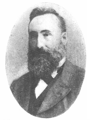
The story of the Schooner Result and it's connection with the Jervis Bay region starts with a South Coast Pioneer, Mr Alexander Mathie. JP., A native of Whitburne, Linlithgow, Scotland he arrived in Australia with his parents in 1857 being 10 years of age. The settled in the Shoalhaven District and engaged in farming and dairying pursuits with success.

He was described as a man of ' dogged perseverance" and soon became possessed of considerable lands in the vicinity of St Georges Basin. The local timber industry had stagnated when Mr Mathie recognising the value of local timber for shipbuilding and the ever growing Sydney market started a sawmill and engaged in the timber trade.  With dogged determination he built his business into a financial success..

Slipping ships was an expensive undertaking, having to take ships to Sydney, costs could amount to 3 pounds per day, so Mathie set about and built his own large modern slipway on the western side of the Basin under the lee of Tallyan Point in close proximity to Tallyan wharf where the schooner usually took in her deck cargo.

Untitled-1

By 1987 he had bought the Schooner Result from New Zealand. The Result was the first vessel to slip on his newly established slipway. Winched clear of the water for maintenance, the schooner was used to ship timber from his Basin mill to Sydney.

Alexander Mathie  died at Tomerong on June 26 from complications from a apoplectic attack.
The fore and aft Schooner Result.
The Result was a huge centre board kauri built boat, 56 tons, without a hold of any kind with only fore and aft cabins below deck for the crew.  The Result was built for shallow waters, havinga  keel that could be raised, her shallow depth and lightweight kauri construction suited the shallow Basin and the ever-changing Sussex Inlet bar.  The timber was loaded onto the deck of the vessel.  The Result would on average make fortnightly trips between ports, she was a very busy ship which required regular maintenance, which was carried out on the Mathie slips.

1891 - She was pulled from the water for some time and completely overhauled.  On her completion a gathering of local people attended the relaunch, with an el fresco supper provided by the ladies.  The blocks were pulled away and the vessel gracefully slipped into the Basin amidst the cheers of the gathering, guests were welcomed aboard and taken on a cruise across the Basin.

By 1891 the Result had shipped over 3 million feet of timber between the Basin and Sydney, mainly shipping ironbark, turpentine, black butt, woolly bark and spotted gum. She was well suited to the trade.  The run to Sydney in favourable conditions taking around 24 hours.  She kept 10 men continuously employed.

1892 The Result had been operating without serious incident for 6 years but was now sitting on the bottom of the sea near the entrance to Sussex Inlet.

image

While trying to enter the bar on a moonlit night around 9 p.m. she struck rocks and was holed, hauling clear of the rocks she quickly sank in deep water without loss of life.
Six weeks later she was refloated and taken 7 miles up the river to her moorings inside St Georges Basin waiting to be hauled up onto the slip for repairs. The accident was first blamed on Mr Mathie who was on board at the time and had suggested to the mate, who was steering, to take a shortcut, which in the dusk appeared to be smooth water but turned out to be a flat reef.
Later the reports were changed with no blame being on the channel, or on the part of any person on board, but because in "wearing" the schooner, she refused to come around fast enough, and was carried upon the rocks by the tide. It was expected the repairs would take three months.

The following year the Result made her final voyage.
1893 September 30 The vessel was on a return trip in ballast from Sydney to St Georges Basin.

12.30p.m The schooner left Sydney under a fresh N.E wind the course steered being S.S.W.

7.45 p.m She passed Kiama the same day where the weather became thick, with a nasty south – east-swell developing, accompanied by a squall from the east.
 
8 p.m The captain relieved the man at the wheel, altered course for half an hour to the south and then brought her out to S.S.W.

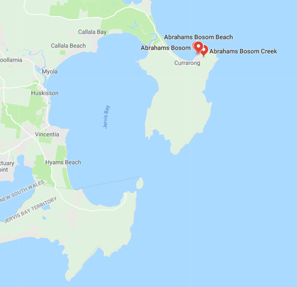
10.30 p.m. The captain sighted land and found that the schooner was in the bight at Abrahams Bosum near Jervis Bay.  He at once called all hands up, and three times they attempted to stay the vessel. She missed each time, however, and the anchor was then dropped, It did not hold, and a minute later the schooner grounded, and ultimately became a total wreck.

The crew affected a landing without incident, taking all their belongings. They remained by the wreck until Sunday and succeeded in securing a quantity of gear from the vessel. The Result was uninsured.
The crew were returned to Sydney by the Steamer Coomonderry.
image


image

Marine enquiry.
Barnard Sholbert, the only witness called, stated that he was the mate of the Result when she went ashore. He had been in her for 13 months, and the last nine months under the present master,  The crew consisted of three all told, the captain, himself and the cook. Passing Kiama the vessel was well off the land, and the green light could hardly be seen. The only reason he could advance to account for the loss of the vessel was the conduct of the captain. The vessel was, he thought, steered on the correct course. He did not know there was any whisky onboard until abreast of Kiama when the captain called told him. After going below, the captain called him up to shorten the sail. The vessel was running wing and wing, and he went forward, took in the square sail, lowered the centreboard and shortened the canvas. When he went to the wind the land was on the weather bow,  She was then put about,  and came close inshore, the captain endeavoured to put her about again,  She missed stays three times, and an anchor and about 30 fathoms of chain let go. Thye anchor, however, would not hold and the vessel drove onto the beach, that was on Saturday night.  The sea was then too heavy
for them to do anything and the vessel became a total wreck on Tuesday. The captain seemed to do all he could to prevent the vessel going ashore. Witnesses had never known her to miss stays before. The captain had been drinking whisky at the time of the wreck, but witnesses could not say he was drunk. The captain had a bottle of whisky on his bunk which the cook said they had better throw overboard.

The captain was not present at this hearing.


image

The Marine Board's Decision.
The Marine Board this afternoon concluded its inquiry into the loss of the fore-and-aft schooner Result, which went ashore and was wrecked off the southern coast on September 30. The board found that the wreck was caused by Walter Graham, the master, in carelessly navigating his vessel by allowing her to run into the Shoalhaven Bight in place of steering her towards her destination along the coast. Captain Graham was, therefore, cited to appear before the board the following day to show cause why his certificate should not be dealt with.

Meaning -  stay. To tack, to bring the ship's head up to the wind for going about; hence to miss stays, is to fail in the attempt to go about.
Centreboard schooner - A centreboard or centerboard (US) is a retractable keel which pivots out of a slot in the hull of a sailboat
Wearing - To turn the ship away from the wind in order to change tacks downwind. All of the rigging turns and rubs during the maneuver, causing the gear to wear.


Two other ships of note have come to grief in this location.
T.S.S Merimbula -  Continue reading.
S.S Plutus –
Continue reading.

As mentioned above, the steamer Commonderry had a colourful exciting life – Continue Reading


image


2 February 2017

Black Diamonds Jervis Bay.

IMG_3605


Black Diamond recovered from the wreck of the Plutus at Currarong..

Did you know?
In the early 1900’s coal was discovered near Jervis Bay, the news motivated capitalists into investing time and money into trying to persuade the Government of the time, to contribute to the many mining schemes and turn the speculation into profit.

image

1874 - A meeting of about thirty gentlemen met at City-Hall for the purpose of hearing a scheme for floating a coal company at Jervis Bay,  it was stated immense seams of coal,  besides other minerals, such as iron, anthracite coal and fire-clay were known to exist. They showed specimens of coal and other minerals from the intended mining sites.  The area concerned was about 22 miles from Jervis Bay, and consisted of 3000 acres of land,  containing two seams of coal,  one 22 feet wide,  and the other 20 feet, besides smaller seams,  and was computed to contain 259 million tons of coal.

The speaker had prepared a scheme for forming a company, a capital of 150,000 pounds would be required,  the chief items of expenditure being:-
Purchase of lease, 11.000 pounds.
New South Wales Government, 7000 pounds.
Proprietary shares, 6000 pounds.
Railway, 25 miles at 3000 ponds a mile, 75,000 ponds.
Locomotives, 20.000 pounds. 
Trucks, 15.000 pounds.
Opening mine, 5000 pounds.
Wharves, 18,000 pounds.
Survey, 7000 pounds.

Against this there were 37.000 acres of land containing 70.000 tons per acre, which would yield 103,600.000 pounds; and by allowing for 1000 tons per day being shipped,  the outlay would give a yearly income of 105.000 pounds.

In it's time the sums being spoken of were quite substantial and the returns on their investment quite lucrative.
The meeting broke up without any decision being arrived at.

Over the following years the interest in the coal deposits and the prospects for development and huge returns were very much on local investors minds.

1884 - A deputation comprising a local doctor, the Mayor of Nowra and the Mayor of Shoalhaven approached the Mining Minister to ask for the use of a diamond drill and the necessary skilled labour, to be supplied free of charge, to bore for coal on Government Land in the vicinity of Jervis Bay.

image

The minister refused the application on the terms mentioned.  -  "After all, prospecting for coal at Jervis Bay was a matter of private speculation,  and the Government had laid down certain regulations upon which the diamond drills would be lent to the public." - he went on to state  - "Our present coal fields were already sufficient to supply demand." -   He acknowledged the importance of future investigation.  " But was inclined to think there was sufficient
enterprise there to pay the cost of the drills."

1890 - A private land holder sunk a bore 103 feet deep on his land a Sassafras,  and in the words of a competent authority, 'is in splendid coal measures." with every indication of soon striking a seam...

Nothing more was heard about this.

image
1900 - Coal deposits were identified in the Jervis Bay Region and there were companies activity pursuing leases for the purpose of coal mining.  One such lease was for the parish of Tiangara immediately west of Jervis Bay where eleven square mile was applied for to take up coal mining. Australian and British investors had inspected these sites near the base of Sassafras Plateau and determined the coal was equal to the best Welch coal for steaming purposes.

image

1902 - The Sassafras area came under consideration as the possible location of the Federal City, and with this some twenty sections were measured off as coal mining sites by capitalists..

1907 – Workable coal seams - The government geologist had identified the occurrence of workable coal seams in this district and being accessible to the fine harbour if Jervis Bay was considered as "One of considerable importance."

1908 - Further exhaustive investigation by mining experts were confident – “That valuable seams exist in the vicinity of the Falls, Jervis Bay."   - This prompted local people assisted by the shire council to urge the Government to sink a bore, to prove that southern coal deposits extend to Jervis Bay.  - "It would be a great factor in opening up the district." -  It was anticipated a positive result would result in the establishment of large smelting works.

1908 - Trial bores refused.
The Clyde Shire Council was informed by the Under Secretary for Mines that the application made by council for trail bores in the neighbourhood  of Jervis Bay cannot be granted.

1911 - No coal of commercial value.  The geological surveyor for the Department of Mines stated  "He was absolutely certain that there was no coal of commercial value south of Mount Kembla.  It may be suitable for coke making. -  “ I am prepared to admit however,  there  may  be a time when it will be necessary to develop even this unpromising source of coal supply."

The statements above didn't deter potential investors or the local council,  they saw it as a way of promoting the districts commercial prospects.

1912 – Links to Federal Port - With the proposed linking of the new Federal Port of Jervis Bay by railway with Canberra,  the interior,  and Sydney,  a Sydney M.P made an application   for 1920 acres of land for the purpose of mining coal in the parish of Tianjara, county of St. Vincent. This was driven by reports from a licensed surveyor employed by  Sydney capitalists to inspect the country seaward side of Sassafras.
He gave the opinion the coal area embraced an extensive area north and south of Pigeon House.
Capitalists were excited by the prospect of the proposed railway to Canberra and Sydney running right through the area concerned, then linking with Jervis Bay.

The surveyor also applied for three leases of 640 acres each,  these adjoined the same leases mentioned beforehand, declaring   -  "The coal in these deposits to be equal to anything in Australia"
"
The rush was on and another investor applied for 320 acres to mine for coal in the same location..

The area applied for was part of that tested 20 years earlier by the Shoalhaven syndicate.  "The Tianjara and Jervis Bay Coal Mining Co."

image
1913 – Jervis Bay Coal Syndicate - Efforts were still being made by local and Sydney investors to develop the coal fields close to the Federal Port,  where the Jervis Bay Coal Syndicate have 1920 acres under lease,  20 miles from Jervis Bay and one mile from the surveyed railway line from the Canberra to Jervis Bay.
The syndicate drove a tunnel 80 feet on a 7 feet seam of coal,  which analysis showed to be of excellent steaming quality.
"The future of the Federal Port as a great naval base is assured,  the opening up of the coal industry there should give a great boost to the district and capital and also help develop other large industries in the success of which  'black diamonds' are such an important factor."

1923 - A Sydney investor pegged out an area of eight square miles near Sassafras for which he has made and application for a lease to mine coal.

Nothing came of the above application.

Back to 1884 - The only record I have found of actual mining was a small operation which did get started at the head of the Clyde River, spurred on by coal being found, particularly after heavy rain amongst the boulders along the river.     A group of 10 men endured unbelievable hardships exploring every possible creek and gully along the river, they eventually found an exposed seam, at the head of the river, which they decided to develop.
Because of the location the work was done by hand, this required the coal to be hauled 600 feet up the side of a steep mountain on the men's back, to be loaded onto waiting bullock teams, the men had to cut steps in the face of the mountain to make the task manageable.

The venture proved a failure as coal was cheap at the time and the long and arduous haulage swallowed up any profits..  Ambitious proposals were made to sink a shaft and haul the coal to level country to be loaded on to a tramway built to Jervis Bay.

Like so many other schemes it did not reach fruition.

Despite continued interest, coal mining never developed in the district, nothing came of the railway or the Jervis Bay Federal Port.   Coal in commercial quantities has never been commercially extracted from the district. 


image


21 December 2016

Wreck of the S.S.Plutus

IMG_3601

On any day.
Today I visited the site of the wreck of the S.S. Plutus, you could easily walk right past the remains sitting in shallow water aprox 30 meters from shore.  Unless you are aware of exactly where she lies you would be hard pressed to pick her resting place from any other part of the beach.    When the conditions are clear and the sea is calm and you know where to look, you can still make out the dark  outline against the golden sands.    Any slight wave action caressing her remains causes swirls of water that stand out from the surrounding calm,  giving away her isolation.

134 years ago it was a very different scene to the one I observed today which greeted a newspaper correspondent who made the considerable effort to travel to the wreck site to report on the loss of the S.S. Plutus..

 
It was a sorry scene you would have witnessed if you had been able to visit the wreck at that time.
 

Correspondent.
‘'The hull of the vessel had parted nearly amidships,  just in front of the bridge.  She was heading S.S.E, with a lurch to port of 20 degrees,  and lying in about 8ft of water.”

 
reconstruction-mock-upReconstruction.
 

The S.S.Plutus was a relatively new vessel, built by T. and W. Smith and launched at South Shields England in April 1982,  just 7 months later she laying broadside to Currarong Beach with waves breaking over her with no hope of getting her off.

The Plutus was described as "strongly put together, so as to adapt her for the heaviest description of cargo".   The best materials had been employed in her construction,  with a view to safety incase of touching rocks,  she carried no stone ballast,  the hull was double bottomed to the extent of 343 tons. 

Described as a scow steamer, schooner rigged, Iron throughout including decks and spars,  812 tons register,  compound steam engines of 135 horsepower.  She was furnished with the newest and most efficient mechanical appliances for cargo haulage.  Coal can be shot into or whipped out of four very large hatches,  designed to ensure rapid dispatch with a coal capacity of 1700 tons, only drawing 14ft 8inches of water enabling her to travel the Yarra River without lightering in the bay.

Owners,  Kish Brothers and a number of other partners of Sunderland England.

She arrived at Newcastle in July 17 1882, to fill the demand for economical well equipped steamers for the ever increasing coal trade.  Chartered  by Mesa's. J. and A. Brown, of Newcastle. and had since been in the Newcastle to Melbourne coal trade in command of Captain Kish.

Captain Kish was a young man of around 27 years of age at the time of the grounding. 

Leaving Newcastle she proceeded south in good conditions, passing Sydney Heads as expected,  the master set her course to S.1/2 W, which should have kept her 10 miles from shore.

When asked about the grounding by a correspondent from the papers.

Captain Kish. - " I had no doubts about my position; I expected and was looking out for Jervis Bay light; there was neither carelessness or neglect on the part of myself, officers or crew."

7p.m the weather was described as thick and hazy with a west wind and a sea in her favour she made good progress down the coast.

8p.m  Captain Kish thought they were around 15 miles off the land moving at aprox 9 knots.  Before leaving the bridge,  Captain Kish gave orders to her observers to look out for the Jervis Bay Light, or Beecroft Head.

8.20 p.m. The master was called on deck by second officer saying that land was right ahead. 

Captain Kish. - 'When I got on deck she was heading S.E.,  with the land on the port bow, I  thought it was a fog bank.  ordered the helm hard a starboard to make sure,  and stopped the engines and reversed them full speed." 

LAND AHEAD!.  was shouted by one of the  four men on watch,  he was in a forward position,  he received no response,   he rushed back to the bridge to raise the alarm,  "but before the way was stopped the vessel struck,  went ashore,  and never came off afterwards."
Firmly wedged in the sand the sea started to break over her,  washing away the bulwarks and driving the ship right up on the beach.  The night was very dark and with the rough sea it was decided to wait until daylight before leaving the ship.

In the hope of attracting attention rockets were fired at intervals of 10 minutes for an hour.

Currarong in those times was a very isolated, location with few permanent inhabitants.

Sunday morning -  The sea was a lot calmer and all hands alighted the vessel by the boats and rowed to shore.  Over a period they landed all movable materials from the wreck. The Captain and crew left for Greenwell Point to raise the alarm,  leaving the chief and second officer in charge of the wreck.

Marine Enquiry.
When asked to explain how the Plutus came to be in the position it found herself in.

The Captain had no explanation.


Captain - 'the course steered should have taken the vessel 10 miles clear at least of the light,  from whence I should have taken a fresh departure.  I cannot in any way account for ar explain the position of the vessel when she struck.' other than to think the compasses were off."


Marine Board Enquiry findings.
After interviewing all the relevant officers and crew and Captain Kish and careful deliberation of all the fact, the Marine board bought down it's findings on the 5th January 1883.


" We find the loss of the vessel was caused through the wrongful act or default of the master, Captain Kish. in carelessly navigating his ship,  and in not taking proper precautions before it got dark of ascertaining her true position.
The boards decision is that Captain Fisk's certificate should be suspended for six months from the date of the wreck."

 
wreck-locationsShe lies close to the beach and within site of the wreck of the T.S.S.Merimbula, which ran headlong into the distant headland and became a total wreck…


50 years later
Coal from the deep.
1925 some 50 years after the Plutus was wrecked, her cargo of Newcastle coal could still be found strewn along the beach adjacent to the remains of the wreck...'the coal burns as well as the present day coal."  - J.D.

134 years later. 2016.
Even today as I did.  you can still find Newcastle coal washed from the wreck,  I found quite a large piece ( 200mm x 100mm x 80mm) sitting on the sand at low tide.
If you dive on the wreck what you see will depend on what the sand has revealed....I have dived the wreck many times over many years,  usually as a passing curiosity on our way to other dive locations.
I have seen it almost covered completely with nothing but a few rusted bits sticking out of the sand,  and other occasions have seen her exposed down to her twisted deck plates with clearly defined hatch ways. Close to shore it’s an easy dive on calm days, but please always dive with a friend.

IMG_3608Newcastle Coal recovered 21st December 2016.
image
_MG_1670Remains of a port hole I recovered from the wreck site in 1996 now in the collection of the Jervis Bay Maritime Museum.
 
IMG_3593Just to the east of the wreck is Plutus Creek, named after the wreck.


image


9 December 2016

On this day –134 years ago

Plutus Creek, Currarong was named after the steamer Plutus,  which ran aground near the present day village of Currarong on December 9 1882.

image
plutus-2005
CaptureThe remains of the wreck are still clearly visable on calm days even today.


image

2 March 2015

A forgotten Town


The Sydney Morning Herald – Tuesday 13 October1908
Shattered dreams, withered hopes.

Extracts from an article that appeared in the above mentioned paper, by a Sydney correspondent reminiscing about South Huskisson (Vincentia) and a general description of Huskisson and the District  when he visited the region in 1867.


'With the exception of Sydney Harbour,” says the ‘'”Nautical Almanac,” ‘'Jervis Bay is perhaps the most perfectly protected sheet of anchorage water in Australia.”

”Anchorage for “ironclads” sounds well for the Federal Port.  Indeed, Jervis Bay is now used chiefly by the ships of the squadron for gunnery.  The men do not land.  But many of the officers say that they enjoy their trips down there, and the wallaby shooting along the wild, beautiful harbour side, actually better than their time in any other port in Australasia.”


Whale in the bay.
”There was whaling in the old days at Jervis Bay – a small town of solid houses just inside the hook of South Head.  The warships anchor at least half a mile from the North Head shore, in “Montague Roads.”  But the safest anchorage is Darling Roads, close under South Head, and Bowen Island.”     There was the old town of South Huskisson.    

 
  whale in the bay  
 

What with whaling and the big timber along the shores, a large ship-building industry sprung up there.  Mr Hardiman who builds ships there for many years, went to Jervis bay in the 60’s.”


  1449-Boat-frame  
 

“The old town was dead when I went there’'. The houses were still standing, and the fruit trees still growing around them.  But doors were broken in and the windows.  There’s nothing of it left now except one big Norfolk Island Pine by the water there,  a long mound which they say was a baker’s shop,  and a few tumbled stones on the beach that look as if a pier may have been there.”

”Jervis Bay in a wonderful big stretch, 8 or 10 miles across.  Just to the south of it is another beautiful basin,  St Georges Basin, nearly landlocked, but not very deep. It opens into Wreck Bay.”

”It’s well called Wreck Bay. The old lighthouse used to be on South Head, where it could not be well seen,  and ship after ship made into Wreck Bay by mistake.   I remember the Walter Hood – an Aberdeen clipper she was – went down with almost all hands on a reef there one awful night. That same storm swept away the farm land on the Shoalhaven River.   I saw the black mud spread over the flats there, and men prodding it with sticks to find the bodies.  The Corangamite and the Rose of Australia were lost there too; and the juniper, coming round with wine; her hull use to wash out occasionally and get covered again. The Plutus – she was wrecked off North Head.”

”As for a railway from inland to the coast, there is no road running to Old Huskisson.  The Old Wool Road used to come down there from Braidwood.   I suppose the old teams bought the wool that way over the Jerrawangala Gap – I think it was – and across to Wandandian and St Georges Basin; and from there to Huskisson,  But the Old Wool Road is overgrown now;  I doubt if you could follow it through the farm lands there.  One or two of the piles of the old wool stores still remain – that’s all.”


Bullock_team


This typifies the type of scene people would have seen as the Bullock teams bought Wool from the Southern Highlands along the Wool Road to South Huskisson. (image public domain)


”The warships get their stores from N. Huskisson at the head of the Bay.  The stores come through by road from Nowra.  North Huskisson used to be a town with a school of 30 children.  That was before the timber was cut out, and when the shipbuilding was brisk.

There is no school there now.  There are not enough children to keep it going.  They go to Tomerong -  a dairying village five miles away.    The main road there – the only road to speak of – is the road from Nowra to Braidwood.”


The remainder of the story related to Canberra and the surrounding district.
But one small item of interest remained, it was the official description of the Crown Lands of Jervis Bay in 1867.


“Jervis Bay itself is 87 miles south of Sydney.   It’s shores are almost uninhabited.”


17 January 2014

The Coastal Steamer Mokau

SS-MOKAU-small
By the 20th century shipping goods and people between ports was a thriving business.

Coastal Shipping was the fastest and most convenient way of transporting people and goods over the great distances between ports right around the world. Australia was a vast country, communities were spread across great distances. Reliable rail and road transport were virtually nonexistent.  The nation's resources needed transporting, wool, timber, oil, coal, silica were all transported by ship.
In the 1900s, coastal steamers made from timber and steel plied the sometimes treacherous coast. Without the weather forecasting equipment we take for granted in this age, these small hard working ships could easily run into trouble. Captains and crews were usually made up of experienced hardened sea going men, use to a life controlled by the elements.

The Australian coastline is littered with shipwrecks, stories and legends, the area around Jervis Bay and Wreck Bay was regarded by captains and crews as a particuarly dangerous place, many vessels were lost. The Corangamite, The Walter Hood, The Wandra,The Plutus, The Merimbula, The Hive, The Summer Cloud are just a few of the many wrecks in the area, a fine collection of relics from some of these ships are on display at the museum.


The Mokau
194 tons 35m x 6,9m x 2,7 meters Built at David Drake Limited in 1901 located at Balmain.
In 1922.


david drake 1

The Coastal Steamers Mokau, was transporting Silica from Ulladulla to Newcastle when she sprung a leak under her boiler, the leak was considered serious enough to seek shelter at the entrance to Sussex Inlet.

The cargo - Silica.
Occurs as the mineral quartz, a major constituent in many igneous and sedimentary rocks.
Bannister Headland at the northern end of Mollymook beach was the site of a silica crushing facility and loading jetty in the early 20th Century. In 1924, a tramway was constructed across Narrawallee Inlet to transport silica from mining leases near Conjola for preparation and shipping. The industry declined during World War II.
Flint Point was the main area mined for silica. Rocks were found to be almost pure silica were transported to Ulladulla, then shipped to Port Kembla and Newcastle to be crushed and made into refractory bricks to line the furnaces of the steelworks.

History of events leading to the loss of the Mokau.

January 18th Red Head:
The Mokau had been engaged in salvaging a punt that had sunk during wharf construction.
This required the Mokau to anchor bow to shore directly over the punt with lines fixed stem and stern.
The punt was raised by means of tackle rigged at the bow, and the ship was then hove in towards the shore, pushing the punt ahead of it, until the punt was on the beach.

garboard_strake-illistration A diver employed by the contactor had stated he saw evidence of damage to the Mokau on the port bow and along the garboard strake and had advised the captain to head straight to Sydney for docking.
Instead, the Mokau headed straight to Ulladulla and loaded with 110 tons of silica rock.

Garboard strake illustration. click to enlarge.

January 19th Ulladulla:

The next morning it was noticed the Mokau was making water much faster than usual, and at lunchtime, the engineer informed the captain that it was about 13 inches per hour, He also stated she was “out of shape” after the loading was completed.

January 19th 4.30pm.
She left port bound for Wollongong, with the fore hatch uncovered, but shortly after leaving the harbour a strong southerly gale broke accompanied by heavy rain, thunder and lightning.

January 19th 6.30pm
The engineer had been continually monitoring the leak and by 6.30pm advised the master to head for the nearest port, They eventually made for Sussex Inlet, and got under the reef in smooth water dropping anchor.

January 20th.
As she was being moved the next day she touched bottom and never came off again. Meanwhile, the engineer pumped the ship dry but the master did not think it safe to go on. Later while moving cargo, water was found rushing in through the deadwood. The captain informed Red Head by telephone as soon as he could.

January 24th.
The underwriter's surveyors arrived to access the damage to the ship.

January 26th
On his advise the crew were landed and the vessel was abandoned by her owners Messrs, Kirton and Earnshaw as a total loss. By then the sea was breaking over the stern, the anchors having carried away, she later came onto the beach and broke her back.

March 14th. The court case.
An enquiry into the circumstances attending the beaching and subsequent wreck of the steamer Mokau. The court found that William Robinson master of the Mokau had been guilty of miss conduct in taking the vessel to sea in the face of an approaching storm in an unseaworthy condition and with her fore hatch uncovered, as a result of which she was compelled to run for shelter in Sussex Inlet, where she became a total loss and was abandoned.
The court called upon Captain Robinson to show cause why his certificate should not be cancelled.

Mokau-wreck-1926--rs

Mokauwreck---rs


wreck photo 2014


The Wreck Now.

inlet3


The narrow entrance to Sussex Inlet is made up of constantly shifting sand bars. Floods and large southerly and easterly swells shift large amounts of sand. 
Sonia Cropper, the owner of the holiday cabins located near the entrance to Sussex Inlet contacted the Museum saying she could see the outline of the Mokau in the shallow entrance to the river.

Sonia was familiar with the story of the Mokau, and this was the first time she had seen any evidence of the wreck appear.

Since then I have dived the wreck a number of times and have put together this short video of the last days of the Mokau and some vision of what remains today of this once proud coastal steamer.


snap-1-small


snap-2-small


Here is the link to a video of the last voyage of the Mokau and what remains underwater of her today. CLICK HERE TO SEE THE VIDEO – best viewed full screen.

David Drake Ship Builder coincidentally died in 1922.


This was only the beginning of this fascinating story, continue reading.

https://youtu.be/f8mNqif3pQE?list=UU_R7tNHlYo50zihH3rVkuAQ

NOTE: best viewed in HD and ENLARGED to full screen.


image

22 October 2013

Wreck of the Steamer Plutus 1882 – Currarong NSW

 Part of this areas Maritime History.

plutus-portholeThis was collected from the sand around the site of the wreck of the Plutus around 1976.
Newspaper Story of the Steamer Plutus
Details of the Plutus.

In those days I use to dive with a true legend in Australian Diving John Sumner.
John is regarded as one of the leading authorities on Australian Shipwrecks and has explored many, many wrecks around the Australian Coastline. He has an unrivaled passion for Wrecks, especially their bells.

We did many dives together over many years, sometimes in difficult conditions with limited visibility and rough sea conditions. John had this amazing ability to find objects where others couldn’t.

John Sumner also has a unique collection of shipwreck postcards.

wreck-site
Wreck Remains – Google Earth.


Australian Geographic historic-shipwrecks-around-australia